Parallel coordinates plot
Parallel Coordinates plot with Plotly Express
Plotly Express is the easy-to-use, high-level interface to Plotly, which operates on a variety of types of data and produces easy-to-style figures. In a parallel coordinates plot with px.parallel_coordinates, each row of the DataFrame is represented by a polyline mark which traverses a set of parallel axes, one for each of the dimensions. For other representations of multivariate data, also see parallel categories, radar charts and scatterplot matrix (SPLOM).
import plotly.express as px
df = px.data.iris()
fig = px.parallel_coordinates(df, color="species_id", labels={"species_id": "Species",
                "sepal_width": "Sepal Width", "sepal_length": "Sepal Length",
                "petal_width": "Petal Width", "petal_length": "Petal Length", },
                             color_continuous_scale=px.colors.diverging.Tealrose,
                             color_continuous_midpoint=2)
fig.show()
Parallel coordinates are richly interactive by default. Drag the lines along the axes to filter regions.
Select the columns to be represented with the dimensions parameter.
import plotly.express as px
df = px.data.iris()
fig = px.parallel_coordinates(df, color="species_id",
                              dimensions=['sepal_width', 'sepal_length', 'petal_width',
                                          'petal_length'],
                              color_continuous_scale=px.colors.diverging.Tealrose,
                              color_continuous_midpoint=2)
fig.show()
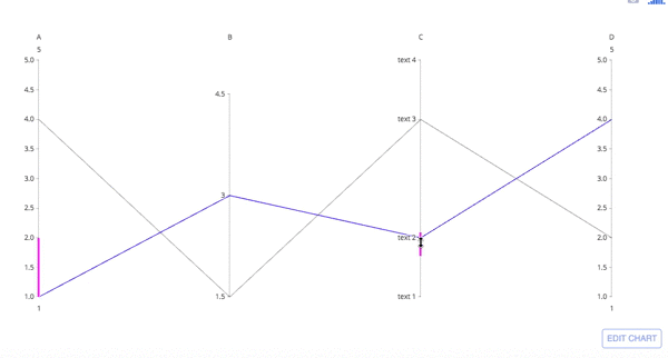
Parallel Coordinates Chart with go.Parcoords
import plotly.graph_objects as go

fig = go.Figure(data=
    go.Parcoords(
        line_color='blue',
        dimensions = list([
            dict(range = [1,5],
                 constraintrange = [1,2], # change this range by dragging the pink line
                 label = 'A', values = [1,4]),
            dict(range = [1.5,5],
                 tickvals = [1.5,3,4.5],
                 label = 'B', values = [3,1.5]),
            dict(range = [1,5],
                 tickvals = [1,2,4,5],
                 label = 'C', values = [2,4],
                 ticktext = ['text 1', 'text 2', 'text 3', 'text 4']),
            dict(range = [1,5],
                 label = 'D', values = [4,2])
        ])
    )
)
fig.show()
Parallel coordinates are richly interactive by default. Drag the lines along the axes to filter regions and drag the axis names across the plot to rearrange variables.
Basic Parallel Coordinates Plot
import plotly.graph_objects as go

import pandas as pd

df = pd.read_csv("https://raw.githubusercontent.com/bcdunbar/datasets/master/iris.csv")

fig = go.Figure(data=
    go.Parcoords(
        line = dict(color = df['species_id'],
                   colorscale = [[0,'purple'],[0.5,'lightseagreen'],[1,'gold']]),
        dimensions = list([
            dict(range = [0,8],
                constraintrange = [4,8],
                label = 'Sepal Length', values = df['sepal_length']),
            dict(range = [0,8],
                label = 'Sepal Width', values = df['sepal_width']),
            dict(range = [0,8],
                label = 'Petal Length', values = df['petal_length']),
            dict(range = [0,8],
                label = 'Petal Width', values = df['petal_width'])
        ])
    )
)

fig.update_layout(
    plot_bgcolor = 'white',
    paper_bgcolor = 'white'
)

fig.show()
Advanced Parallel Coordinates Plot
import plotly.graph_objects as go

import pandas as pd

df = pd.read_csv("https://raw.githubusercontent.com/bcdunbar/datasets/master/parcoords_data.csv")

fig = go.Figure(data=
    go.Parcoords(
        line = dict(color = df['colorVal'],
                   colorscale = 'Electric',
                   showscale = True,
                   cmin = -4000,
                   cmax = -100),
        dimensions = list([
            dict(range = [32000,227900],
                 constraintrange = [100000,150000],
                 label = "Block Height", values = df['blockHeight']),
            dict(range = [0,700000],
                 label = 'Block Width', values = df['blockWidth']),
            dict(tickvals = [0,0.5,1,2,3],
                 ticktext = ['A','AB','B','Y','Z'],
                 label = 'Cyclinder Material', values = df['cycMaterial']),
            dict(range = [-1,4],
                 tickvals = [0,1,2,3],
                 label = 'Block Material', values = df['blockMaterial']),
            dict(range = [134,3154],
                 visible = True,
                 label = 'Total Weight', values = df['totalWeight']),
            dict(range = [9,19984],
                 label = 'Assembly Penalty Wt', values = df['assemblyPW']),
            dict(range = [49000,568000],
                 label = 'Height st Width', values = df['HstW'])])
    )
)
fig.show()
Reference
See function reference for px.(parallel_coordinates) or https://plotly.com/python/reference/parcoords/ for more information and chart attribute options!